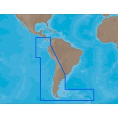
4D SA-D500 Costa Rica to Chile to Falklands
C-MAP charts have long been held in high regard by boaters because they combine aesthetically pleasing vector electronic charts with reliable sources. With the backing of Jeppesen's parent company Boeing, a well-respected multibillion dollar global company, boaters can be assured that C-MAP charts are of the highest standard.
C-Map 4D will provide boaters with charts packed additional features such as raster chart views or Satellite images to maximize situational awareness.
Coverage Area:
Costa Rica to Chile and the Falklands
Features:
- Vector cartography
- Tidal heights
- Currents/Tidal flows
- Animated currents
- Marina charts
- C-Marina ports database
- California MPAs
- Coastal Roads
- Aerial Photos
- Land Elevations
- NavAids
- Multi-language charts
- TrueType font
- Depth Contours
- Online updates
- Explorer® charts
- Wavey Line charts
Product : C-MAP 4D SA-D500 COSTA RICA TO CHILE TO FALKLANDS
Manufacturer : C-map
Manufacturer Part No : SA-D500
UPC : 686074003453
Product : C-MAP 4D SA-D500 COSTA RICA TO CHILE TO FALKLANDS


